

RF electromagnetic field mapping system : MapEM | Wavecontrol

Vehicle-mounted RF electromagnetic field mapping system for city-scale exposure assessment, sensitive point detection and georeferenced field level reporting.
The MapEM system is designed to create RF electromagnetic field level maps over large areas, including urban environments and public infrastructure zones. It combines a MonitEM monitoring device installed on a vehicle with dedicated electromagnetic mapping software.
As the vehicle moves through the area, the system measures electric field strength in V/m and associates the results with geographic position data. This provides a clear, field-based view of RF exposure levels at street level.
MapEM is suitable for technical teams requiring a practical drive test solution for RF exposure assessment, public communication, infrastructure follow-up and comparison of electromagnetic field levels over time.
Advantages
- Large-area RF assessment: designed for electromagnetic field mapping across cities or extended geographic zones.
- Vehicle-mounted measurement: the monitoring device can be installed on a vehicle roof using a magnetic base for field campaigns.
- Georeferenced results: measurement data can be downloaded in Access, KML or CSV format.
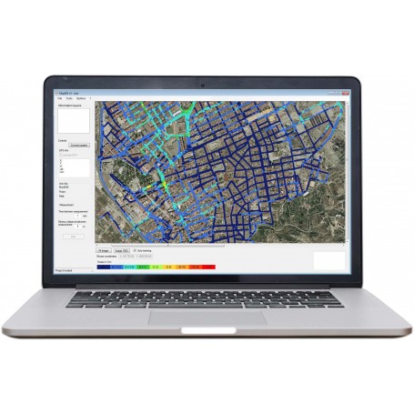
- Visual field level maps: the software superimposes measured levels onto a map for clear technical analysis.
- Year-on-year comparison: supports monitoring of changes linked to infrastructure or technology evolution.
- Sensitive point detection: helps identify locations with higher RF field levels for further investigation or corrective action.
- ITU-T K.113 compliance: suitable for RF exposure drive test applications aligned with this recommendation.
Main characteristics
- System architecture: MonitEM monitoring device with electromagnetic mapping software.
- Measurement type: isotropic RMS field measurement.
- Frequency range: depending on the selected field probe.
- Probe system: interchangeable probes from 100 kHz to 90 GHz.
- Sampling frequency: 1 measurement per second.
- Calibration: ISO 17025 accredited calibration.
- Operating temperature: -25 °C to +60 °C.
- Data transfer: external USB connector.
- Memory: Micro SD, 1 GByte, plus Eeprom.
- Power supply: 12 VDC connected to vehicle and internal battery.
- Software compatibility: Windows operating system.
- Results: display software and database.
- Recommended maximum speed: 50 km/h.
- Dimensions: 70 x 40 x 8 cm.
- Weight: 8 kg.
- Environmental protection: IP66.
- Installation kit: magnetic base for easy installation and removal from the vehicle roof.
- Display software: interface that superimposes measurement levels on the map.
- Coding: editable scale by colour and values.
- Data downloading: georeferenced data in Access, KML or CSV format.
- Exportation: level map images in JPG format.
Compatible field probes
MapEM is compatible with a range of E-Field and H-Field probes. The probes are plug and play and supplied with individual ISO 17025 accredited calibration. The exact frequency coverage depends on the selected probe.
- WPF3: E-Field probe, 100 kHz - 3 GHz.
- WPF6: E-Field probe, 100 kHz - 6 GHz.
- WPF8: E-Field probe, 100 kHz - 8 GHz.
- WPF18: E-Field probe, 300 kHz - 18 GHz.
- WPF40: E-Field probe, 1 MHz - 40 GHz.
- WPF60 / WPF60S: E-Field probe, 1 MHz - 60 GHz.
- WPF90: E-Field probe, 30 MHz - 90 GHz.
- WPH60: H-Field probe, 300 kHz - 60 MHz.
- WPH1000: H-Field probe, 30 MHz - 1000 MHz.
Typical applications
- RF exposure drive test campaigns in urban or semi-urban areas.
- Electromagnetic radiation mapping at street level across large areas.
- Public exposure assessment for municipalities, telecom stakeholders and technical authorities.
- Detection of sensitive points showing higher electromagnetic field levels.
- Monitoring of infrastructure evolution through year-on-year comparison.
- Visual communication of electromagnetic field exposure using mapped measurement results.
Why choose MapEM
MapEM provides a practical and field-oriented solution for RF electromagnetic exposure mapping. Its vehicle-mounted configuration enables efficient coverage of large areas, while the software transforms measurement data into visual and georeferenced field level maps.
The system is especially relevant when technical teams need to combine repeatable measurements, ISO 17025 accredited probe calibration, street-level RF exposure visibility and clear reporting outputs in standard formats such as KML, CSV and JPG.
With its interchangeable probe architecture covering applications from 100 kHz up to 90 GHz, MapEM can be configured according to the required frequency range and field type.
REQUEST A QUOTE
8 other products in the same category:


Isotropic electric field probe - 1 MHz to 40 GHz: WPF40


Personal EMF monitor - H-field from DC to 400 kHz: WaveMon LF-400

Personal RF monitor - 100 kHz to 60 GHz: WaveMon RF-60


Isotropic electric field probe - 100 kHz to 8 GHz: WPF8
