
Scrubberless Ozone Monitor without NO
PRICE ON REQUEST


Air quality limit values for NO2, O3, NO and particulate matter are systematically exceeded in many cities. In this context, Bettair Cities has developed the bettair Air Quality Mapping (bAQM) service with the aim of providing information on air quality at intra-urban level.
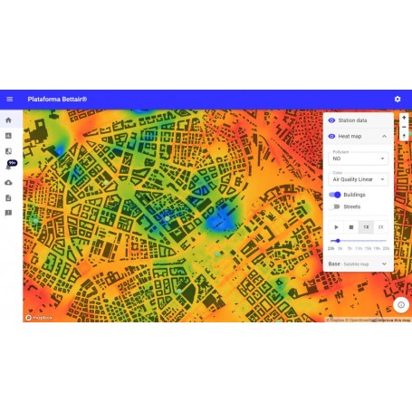
Air quality limit values for NO2, O3, NO and particulate matter are systematically exceeded in many cities. In this context, Bettair Cities has developed the bettair Air Quality Mapping (bAQM) service with the aim of providing information on air quality at intra-urban level. This service allows quantifying and understanding the exposure of citizens to pollutants, assessing the impact of air quality improvement measures and improving their planning. All this is possible thanks to accurate air quality predictions extracted from urban scale (street level) air quality models. The BAQM service generates pollution maps using an urban air quality model based on established scientific models and can reach a spatial resolution of up to one cubic meter. This model takes into account emissions from traffic and local industry, as well as background pollution carried by the wind from outside the city, and allows accurate interpolation of what is happening in city streets and squares. All this from measurements made by any type of air quality measurement instrument. The data obtained by this model make it possible to estimate the actual traffic emissions of each street segment and this allows to disaggregate the contributions of the different emission sources on each point of the map.


